skyline

Hong Kong Skyline, Victoria Harbour Hong Kong
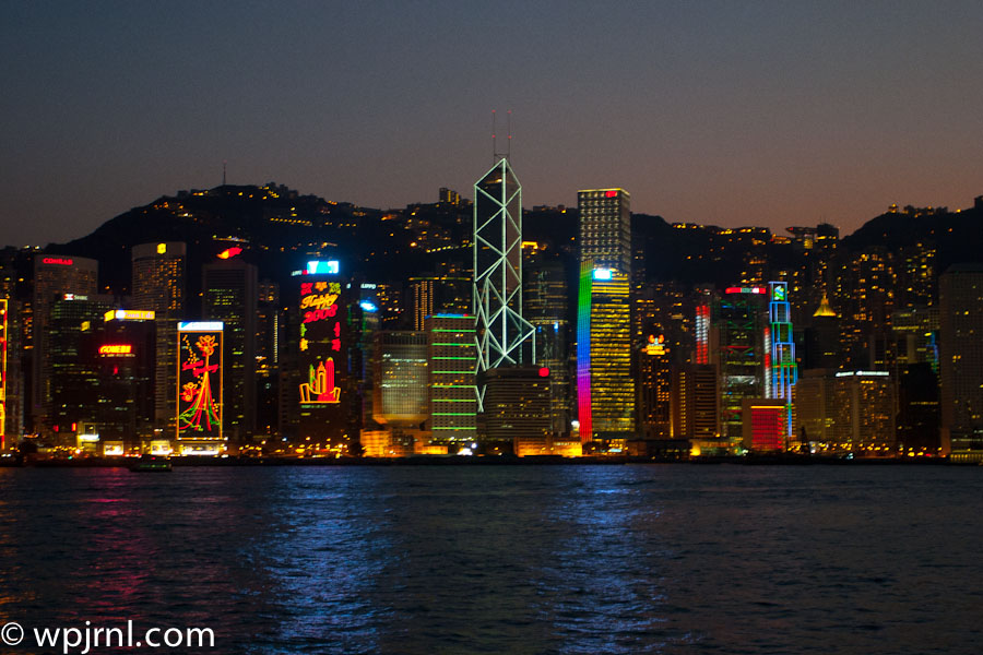
Hong Kong Skyline, Victoria Harbour Hong Kong
One of the world’s most spectacular urban skylines illuminated against the night sky, showcasing Hong Kong’s iconic architecture and vibrant energy.

Hong Kong’s skyline is a breathtaking testament to the city’s status as a global financial powerhouse and cultural beacon. As the sun sets, the harbour comes alive with thousands of lights reflecting off the water, creating an enchanting display that has captivated visitors for decades. The iconic Bank of China Tower, with its distinctive triangular lattice design, stands prominently among gleaming skyscrapers, each contributing to a mesmerizing urban landscape that blends ultramodern architecture with traditional Chinese culture. This is not just a city skyline—it is a living, breathing monument to ambition, innovation, and the relentless energy of Hong Kong itself.

Highlights

  • The iconic Bank of China Tower with its distinctive geometric design dominating the skyline
  • Vibrant neon signs and colorful building illuminations reflecting Hong Kong’s dynamic commercial culture
  • Panoramic views across Victoria Harbour with the New Territories and hills visible in the background
  • The illuminated waterfront creating a mirror effect of thousands of city lights on the water
  • A blend of colonial heritage and ultra-modern architecture showcasing Hong Kong’s evolution

What to Do

  • Visit the Star Ferry terminal for the classic view of the skyline from the water at sunset
  • Experience the Symphony of Lights multimedia show celebrating the skyline each evening
  • Take the Peak Tram to Victoria Peak for panoramic views overlooking the entire harbour
  • Explore the buildings up close, including the Bank of China Tower and other iconic structures
  • Dine at waterfront restaurants and rooftop bars with unobstructed skyline views

Best Time to Visit

October to November and December to February offer the clearest skies and most comfortable temperatures. Twilight hours (just after sunset) provide the most magical photography conditions when the sky transitions from blue to dark while city lights are at their brightest.

Getting There

Hong Kong is served by Hong Kong International Airport. The skyline is best viewed from the Tsim Sha Tsui waterfront, Victoria Peak, or via Star Ferry crossing Victoria Harbour. Public transportation including MTR, buses, and ferries connect all major viewpoints.

Visitor Tips

  • Visit during twilight hours for the best photography—too early and the sky is too bright, too late and details are lost
  • The Star Ferry crossing provides an up-close experience of the skyline from the water for an affordable price
  • Bring a camera with good low-light performance; tripods are helpful for night photography
  • Waterfront areas can be crowded during peak hours; arrive early or visit weekdays for better vantage points
  • Many rooftop bars and restaurants offer premium viewing experiences with food and beverages

Nearby

  • Victoria Peak Lookout, Hong Kong’s highest vantage point
  • Star Ferry terminals connecting Hong Kong Island and Kowloon
  • The Harbourfront Promenade with walking paths along the water
  • Central District’s historic architecture and colonial landmarks
  • Museums and cultural institutions including the Hong Kong Museum of Art

Hong Kong’s skyline is more than just a collection of buildings—it is a symbol of human ambition and cultural resilience. Standing before this illuminated landscape at night, you witness not merely a city, but a testament to innovation, determination, and beauty. Whether you’re a photographer chasing the perfect shot, a traveler seeking iconic experiences, or simply someone who appreciates architectural splendor, Hong Kong’s skyline will leave an indelible impression and remind you why this extraordinary city deserves its place among the world’s most unforgettable destinations.

Location Map

Hong Kong Skyline, Victoria Harbour Hong Kong Read More »
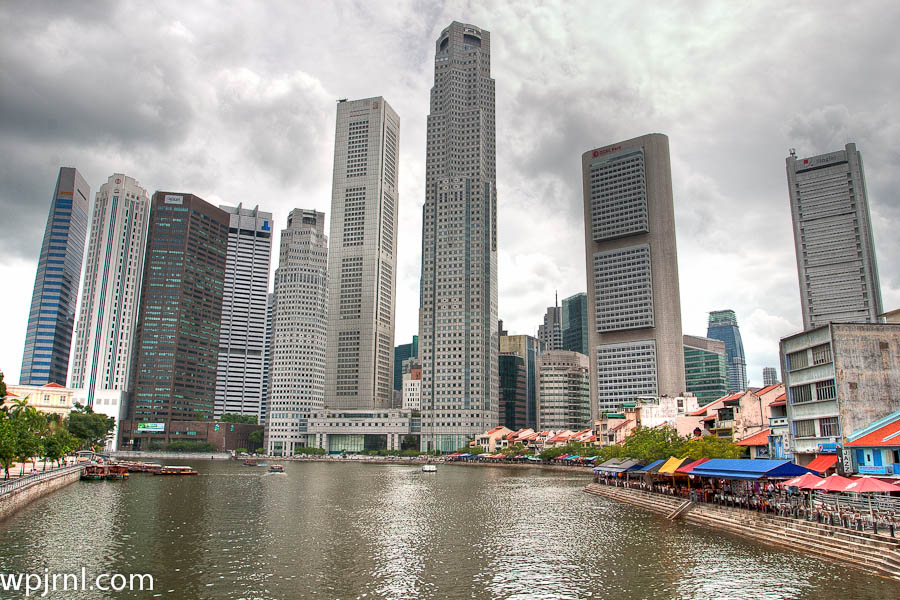
Singapore Skyline & River, Central Business District Singapore

Singapore Skyline & River, Central Business District Singapore
A stunning urban landscape where futuristic skyscrapers meet vibrant riverside culture along the heart of Singapore’s CBD.

The Singapore skyline is one of Asia’s most iconic and dynamic urban landscapes, showcasing a perfect blend of modern architecture and bustling waterfront life. Dominated by gleaming high-rise towers and punctuated by the historic Singapore River, this view captures the essence of Singapore’s transformation into a global financial hub. The skyline reflects the city-state’s remarkable development over decades, from a colonial trading port to a gleaming metropolis that seamlessly integrates commerce, culture, and green spaces.

This vantage point along the Singapore River reveals the city’s characteristic harmony between progress and tradition. The colorful heritage buildings and bustling river markets visible in the foreground contrast beautifully with the soaring contemporary towers, creating a visual narrative of Singapore’s evolution. The overcast tropical sky adds drama to the scene, highlighting the city’s subtropical climate and vibrant energy.

Highlights

  • Iconic modern skyscrapers including Marina Bay’s distinctive towers and the distinctive tall cylindrical buildings
  • Singapore River with its active boat traffic and historic waterfront character
  • Vibrant riverside markets and colorful traditional shophouses creating cultural contrast
  • World-class financial district housing major international banks and corporations
  • Perfect urban-nature balance visible from strategic viewpoints throughout the city

What to Do

  • Walk along Singapore River and explore the riverside promenade for photo opportunities
  • Visit nearby Marina Bay attractions including Marina Bay Sands and ArtScience Museum
  • Explore Boat Quay and Clarke Quay for restaurants, bars, and heritage experiences
  • Take a river cruise to experience the skyline from the water
  • Visit museums and cultural sites in the surrounding CBD area

Best Time to Visit

December to February offers cooler, drier weather ideal for exploring the waterfront and enjoying outdoor activities without intense heat.

Getting There

Singapore is easily accessible via Changi Airport, one of Asia’s busiest hubs. The MRT (Mass Rapid Transit) system efficiently connects the airport to the CBD. Most riverside viewpoints are within walking distance of major MRT stations like Raffles Place or Marina Bay.

Visitor Tips

  • Visit early morning or late afternoon for the best lighting and less crowded conditions for photography
  • Bring sun protection and stay hydrated due to Singapore’s tropical heat and humidity
  • The riverside promenade is best explored on foot to discover hidden gems and local eateries
  • Consider a guided river tour to learn about Singapore’s maritime history
  • Visit during weekdays to avoid weekend crowds at popular viewpoints

Nearby

  • Marina Bay Sands Hotel and observation deck for elevated skyline views
  • Merlion Park, Singapore’s most iconic landmark
  • Gardens by the Bay with its futuristic Supertree Grove
  • ArtScience Museum at Marina Bay Sands
  • Raffles Hotel, a historic luxury landmark

The Singapore skyline stands as a testament to human ambition and urban planning excellence. Whether you’re a photography enthusiast, architecture lover, or simply curious about one of the world’s most successful modern cities, the skyline and riverside offer an unforgettable experience. Come witness the harmonious blend of innovation and tradition that makes Singapore a must-visit destination for travelers seeking to understand the future of urban development.

Location Map

Singapore Skyline & River, Central Business District Singapore Read More »

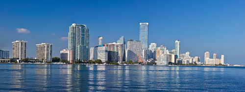
Miami Skyline Panorama, Florida USA

Miami Skyline Panorama, Florida USA
An iconic waterfront vista showcasing Miami’s gleaming modern skyline and vibrant urban landscape.

Miami’s stunning skyline is one of the most recognizable urban panoramas in the United States, featuring a dramatic collection of high-rise towers that reflect the city’s rapid development and cosmopolitan character. Viewed from Biscayne Bay, the skyline presents a breathtaking blend of contemporary architecture, luxury residential towers, and commercial buildings that define the city’s skyline. The crystal-clear waters of the bay provide a perfect vantage point to appreciate the scale and beauty of Miami’s downtown district and surrounding neighborhoods.

Highlights

  • Iconic skyline with modern glass and steel towers reflecting in Biscayne Bay
  • Clear blue waters showcasing the contrast between urban development and natural beauty
  • Diverse architectural styles representing Miami’s growth and cosmopolitan status
  • Perfect photography location for capturing the city’s grandeur

What to Do

  • Take a boat tour or cruise around Biscayne Bay to view the skyline from water level
  • Photograph the skyline from various vantage points including South Pointe Park
  • Visit waterfront restaurants and bars along the bay for dining with skyline views
  • Explore the downtown Miami district and nearby neighborhoods on foot
  • Enjoy sunset views when the buildings are beautifully illuminated

Best Time to Visit

November to April offers the most pleasant weather with clear skies and comfortable temperatures, ideal for outdoor photography and bay activities.

Getting There

Miami is easily accessible by air via Miami International Airport. Once in the city, rent a car or use public transportation to reach Biscayne Bay and waterfront viewing areas.

Visitor Tips

  • Visit during golden hour (sunrise or sunset) for the best photography lighting and colors
  • Bring binoculars to spot boats and wildlife in the bay while enjoying the skyline
  • Check weather conditions for clear visibility before planning your viewing visit
  • Consider visiting from a boat tour for a unique perspective of the cityscape

Nearby

  • South Pointe Park with pristine beaches and jetties
  • Wynwood Walls street art district
  • American Airlines Arena and Bayside Marketplace
  • Vizcaya Museum and Gardens
  • Miami Beach and Art Deco Historic District

Miami’s gleaming skyline is a testament to the city’s dynamic energy and continued evolution as a major global metropolis. Whether you’re a photography enthusiast, travel lover, or simply seeking to experience one of America’s most vibrant urban landscapes, the Miami panorama offers an unforgettable spectacle that captures the spirit and ambition of this remarkable coastal city.

Location Map

Miami Skyline Panorama, Florida USA Read More »

Scroll to Top