
Toronto Lakeshore and QEW, Toronto Canada
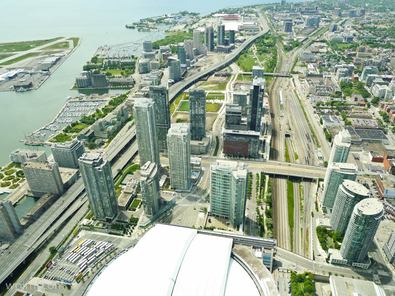
This stunning aerial view captures Toronto’s lakeshore district and the Queen Elizabeth Way (QEW) interchange, showcasing the city’s remarkable urban landscape and strategic position on Lake Ontario. The image reveals how Toronto has evolved as a major metropolitan hub, with gleaming residential and commercial towers rising alongside complex highway systems that connect the Greater Toronto Area. The contrast between the serene waterfront, bustling city center, and intricate transportation networks illustrates Toronto’s role as Canada’s largest city and a vital economic engine.
Highlights
- Aerial view of Toronto’s downtown waterfront with Lake Ontario and harbor facilities
- The Queen Elizabeth Way (QEW) major highway interchange connecting Toronto to Niagara Falls and Southern Ontario
- Modern high-rise residential and commercial developments in the downtown core
- Green spaces and parks integrated throughout the urban landscape
- Toronto’s complex transportation infrastructure including elevated highways and rail corridors
What to Do
- Explore the waterfront attractions including museums, galleries, and entertainment venues along Lake Ontario
- Visit the Ripley’s Aquarium and CN Tower for panoramic city views
- Walk along the Toronto Waterfront Trail for cycling, jogging, or leisurely strolls
- Discover downtown Toronto’s diverse neighborhoods including St. Lawrence, Distillery District, and Entertainment District
- Experience the city’s cultural institutions, restaurants, and shopping districts
Best Time to Visit
Late spring through early fall (May-September) offers the best weather for waterfront activities, though winter provides a different urban charm with potential lakefront snow scenes.
Getting There
Toronto is accessible by air via Pearson International Airport, by train through Union Station, and by car via the QEW and other major highways. The city has extensive public transit via the Toronto Transit Commission (TTC).
Visitor Tips
- The QEW is a major commercial route; expect congestion during rush hours if driving
- Use the TTC subway, streetcar, or bus system to navigate downtown without a car
- The Waterfront Trail offers excellent views and is best explored on foot or by bicycle
- Check weather conditions, especially in winter, before planning waterfront visits
- Parking downtown can be expensive; use paid lots or public transit
Nearby
- CN Tower and Entertainment District
- St. Lawrence Market and Distillery District
- Harbourfront Centre and Toronto Islands
- Casa Loma historic mansion
- Ripley’s Aquarium and Marine Museum
Toronto’s lakeshore and transportation corridors represent the lifeblood of Canada’s largest city, where modern architecture meets natural beauty and urban energy flows seamlessly across the landscape. Whether you’re drawn to the waterfront’s cultural attractions, the vibrant downtown core, or simply want to experience one of North America’s most dynamic cities, Toronto offers an unforgettable blend of urban sophistication and lakeside charm.
Location Map
Toronto Lakeshore and QEW, Toronto Canada Read More »